
Karst Characterization
| PROJECT NAME & LOCATION | DATE STARTED | DATE COMPLETED | |||||
| Woodville Karst Plain Characterization North Florida |
July, 2002 | August, 2010 |
| ACTIVITY TITLE | APPROXIMATE CONTRACT VALUE | |||
| Groundwater Tracing & Modeling | $1,260,000 |
| CLIENT NAME & ADDRESS | TECHNICAL CONTACT | |||
| Florida Geological Survey Florida Department of Environmental Protection Tallahassee, Florida |
Dr. Rodney DeHan (850) 488-9380 Rodney.DeHan@dep.state.fl.us |
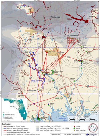
Map of the WKP showing mapped underwater caves
(blue), tracer-defined groundwater flow paths (red), springs (green stars), swallets (red dots), streams (brown and light blue lines), and the distribution and thickness of an upper confining layer (shades of gray).
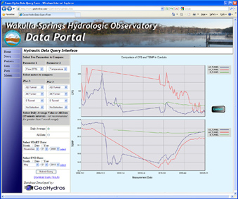
Our quantitative tracing has revealed extremely rapid groundwater flow to Wakulla Spring from several sources of contamination including a swallet that receives 60% of Tallahassee's runoff and the City's waste water spray field; identified the hydraulic mechanisms responsible for varying source water contributions to the spring discharge; and a mechanism responsible for extensive saltwater intrusion to the upper Florida aquifer via large conduits that extend to coastal springs. Tracer-defined flow paths and velocities combined with head, flow, and parameter data being collected from an instrument network installed in various parts of the underwater cave system are being used to develop a new numerical karst groundwater modeling process.
Traces include:
- Fisher Creek swallet to the Leon Sinks cave system
(1.2 miles/0.51 mi/day); - Black Creek swallet to the Leon Sinks cave system
(1.6 miles / 0.50 mi/day); - Leon Sinks cave system to Wakulla cave and
Wakulla Spring (10.6 miles / 1.2 mi/day); - Ames Sink, which receives ~60% of the runoff from Tallahassee, to Indian, Wakulla, and Sally Ward Springs
(~6 miles/ ~0.25 mi/day) - Tallahassee's waste water spray field to Wakulla, Springs (~11 miles / ~0.2 mi/day).
- Lost Creek swallet to both Spring Creek and Wakulla, Springs (0.2 – 1.2 mi/day).
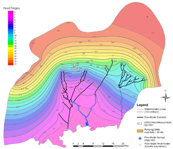
Model simulated head field and saturated conduit network for the upper Floridan aquifer in the WKP.
The numerical modeling work being performed here is revolutionary because it uses a dual-permeability framework to simulate conduit and matrix flow, calibrates to discrete spring discharges as well as heads, and simulates the location and size of the conduits through the calibration process. The modeling techniques devised here are intended to establish new protocols for modeling in karstic parts of the aquifer throughout the rest of the State.
Web interface providing graphical access to the data being collected from longterm monitoring stations.
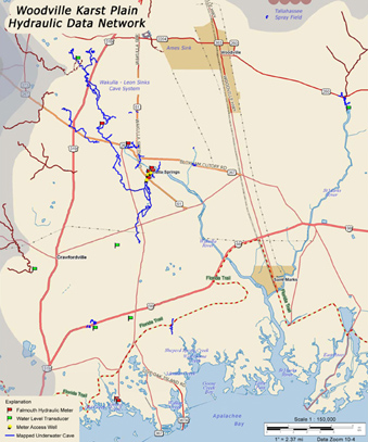
Map showing the location of hydraulic
meters and water level transducers in the WKP.
This project is widely recognized as ground-breaking in terms of its contribution to our understanding of karstic controls on groundwater flow in the upper Floridan aquifer. The tracing results have been instrumental in land-use decisions including the City of Tallahassee's decision to upgrade to an advanced wastewater treatment system at the cost of approximately $200 million; and Wakulla County's decisions on where to delineate a springs protection zone in their zoning ordinances. In addition, the modeling work performed here has defined the methodologies necessary to develop an effective numerical model of karstic groundwater flow and was the precursor to the model completed for the Western Santa Fe River Basin. The fact that this project has persisted in the face of severe budget cuts is testament to its success and perceived utility to the state of Florida.