
FEFLOW
WASY-DHI FEFLOW
The Geohydros Modeling Group has more than 8 years of experience in the use of DHI-Wasy FEFLOW software including the most current version, 6.0. FEFLOW is our software of choice when developing groundwater flow or contaminant transport models because of its superior ability to solve large, sparse matrix systems using PCG-type or algebraic multigrid solvers and because of the flexibility of finite element gridding when simulating systems with complex geologic and hydrologic characteristics. In addition, FEFLOW is fully integrated with ArcGIS allowing for fast and accurate model design and time efficient model calibration and scenario runs. The following sections provide brief examples of our group’s FEFLOW skill sets and how those skills have been applied successfully for our clients.
Discrete Element Features
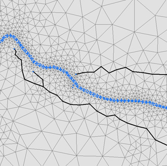
- Developed dual-permeability model using discrete element package to simulate conduit and matrix flow in a karst aquifer (right).
- Karst conduits defined as two-dimensional (horizontal and vertical) linear elements assigned along mesh element limbs.
- Conduits defined between known swallets (infiltration nodes) and springs (discharge nodes) and up-gradient from springs into matrix.
- Flow through conduits defined using Manning-Strickler equation.
- Cross-sectional area used to define capacity of conduit conveyance.
- Roughness factor used to control velocity of water flow (degree to which feature represents a single conduit or zone of conduits).
- Conduit locations and dimensions determined through calibration to groundwater levels, spring discharges, and tracer-defined groundwater velocities.
Free Surface Modeling & Contaminant Transport
- Used free and movable surface option to simulate transport through variably saturated hydrostratigraphic units and units that pinch out laterally across large model domains.
- Used shock capturing (non-linear anisotropic damping) to stabilize transport simulations affected by numerical oscillations.
- Simulated both simple mass transport and reactive transport through 2D and 3D groundwater flow model domains.
- Simulated both point source and non-point source contaminant transport through 2D and 3D groundwater model domains including nitrate transport through karst aquifers and CVOC transport through extremely heterogeneous mixed glacial surficial aquifers.
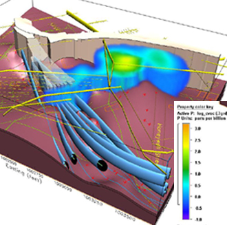
- Exported FEFLOW mass transport results by time-step to EarthVision™ (right) to visualize 3D mass transport relative to underground structures and to estimate resulting impacted earth volumes.
Complex Mesh Designs
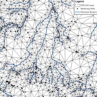
- Integrated FEFLOW mesh building with ArcGIS to facilitate complex mesh design and refinement.
- Developed complex meshes to simulate lateral and vertical geometries of complex natural and man-made structures that impact groundwater flow including dendritic karst conduits that converge to springs and rivers (right).
- Simulated features include: thin, discontinuous lenses of different material properties, large domes and dikes, steeply dipping lithologies with varying material properties; streams, rivers, springs, and lakes; and sewers and grout walls.
- Ensure that all meshes conform to minimum element angle criteria to promote convergence and minimize model errors.
- Integrate mesh design with EarthVision™ such that lithologic heterogeneities can be defined directly from detailed geologic modeling.
Particle Tracking
- Use 2D and 3D backward particle tracking to define capture zones for wells and springs.
- Use 3D particle tracks to define recharge areas (contributing zones) for wells and springs.
- Use 2D particle tracks to delineate traditional EPA Zone II wellhead protection zones.
- Export 3D particle tracks to EarthVision™ to develop animations showing flow paths through geologic structure.
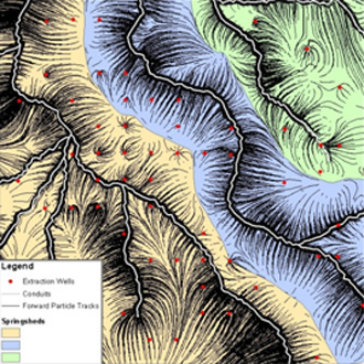
- Use forward particle tracking to delineate groundwater basins, springsheds, and vulnerability zones such as contributing zones to conduits that convey groundwater to springs and rivers (right).
- Export 2D particle tracks to ArcGIS for map and figure production.