
MODFLOW
MODFLOW (GMS)
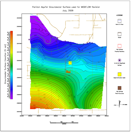
The GeoHydros Modeling Group has over fifteen years experience using MODFLOW, MT3DMS and associated modules to provide answers to a range of groundwater flow as well as 2D and 3D contaminant fate and transport questions. MODFLOW is the US Geological Survey’s modular finite-difference computer code that solves the groundwater flow equation, and has been repackaged with a graphical interface by several software development companies. GeoHydros licenses the most recent version of GMS (10), developed by AquaVeo, and also maintains a license of Groundwater Vistas. In addition, the GeoHydros Group has extensive experience with several MODFLOW modules that we use to address more complex problems including: MT3DMS (multi-species mass & reactive transport in 3D) , SEEP2D (a finite-element cross-sectional modeling package), PEST (parameter estimation / optimization), MODPATH (particle tracking), RT3D (reactive transport in 3D), and T-PROGS (transition probability geostatistical package for lithologic modeling).
Parameter Estimation (PEST)
- A model-independent, non-linear parameter estimator. The purpose of PEST is to assist in data interpretation, model calibration, and predictive analyses.
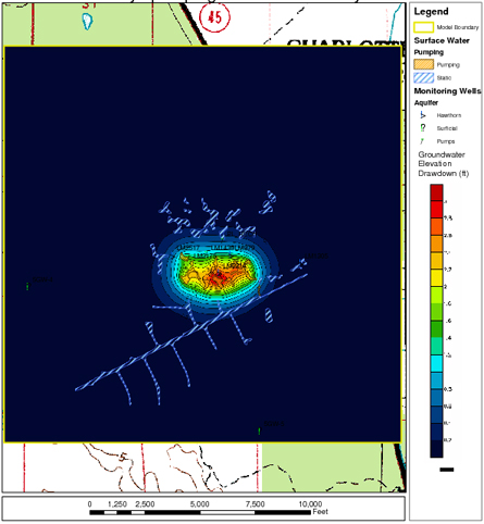
- Used PEST to delineate high permeability zones in a karst aquifer by optimizing the permeability structure to achieve a best-possible calibration to groundwater levels recorded in a dense monitoring well network (right shows resulting steady-state flow field).
- GMS PEST allows modeler to revise parameter settings such as permeability zone delineations during the optimization process and to assign pilot points to provide a continuous rather than stepwise distribution of parameters where appropriate.
- Use composite and relative sensitivity reporting to rank the significance of parameters to the final model results.
Drawdown / Zone of Influence Delineation
- Used GMS MODFLOW to predict the cone-of-depression created by proposed well installations on a water table surface (right).
- Developed scenario analyses to predict impact of pumping on private supply well water levels in confined and unconfined aquifers; and impacts to wetland water levels and hydroperiods in unconfined aquifers during wet, dry, and average conditions.
- Developed transient models to determine threshold time periods in support of permit application processes.
- Integrated model construction and output processes with EarthVision™ and ArcGIS to facilitate model framework construction in complex geologic settings, map and figure production, as well as definition of surficial features into the groundwater simulation such as River, Lake, Drain, General Head, Well, Horizontal Flow Barrier, Stream, Time Variable Specified Head, Recharge and Evapotranspiration boundary conditions.
Mounding Evaluation & Prediction
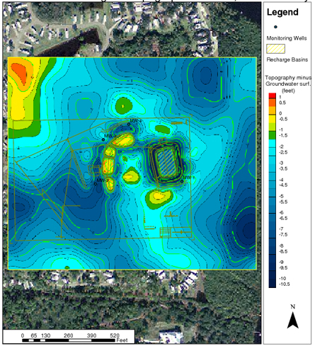
- Used GMS MODFLOW to quickly evaluate the potential impact of engineered infiltration basins on surficial aquifer water levels (right).
- Rapidly developed quantitative scenario analyses to provide clients and regulators with map-based predictions that facilitated design and permitting decisions.
- Used scenario analyses to test effectiveness of proposed mitigation strategies when the proposed activities were predicted to generate unacceptable surficial groundwater levels or flooding.
- Performed similar analyses to determine the transient effects on adjacent wetlands of drawing down engineered lake features to supply dry-season irrigation water.
Mass Transport (MT3DMS)
- Simulates multi-species transport by advection, dispersion, and chemical reactions of dissolved constituents in groundwater.
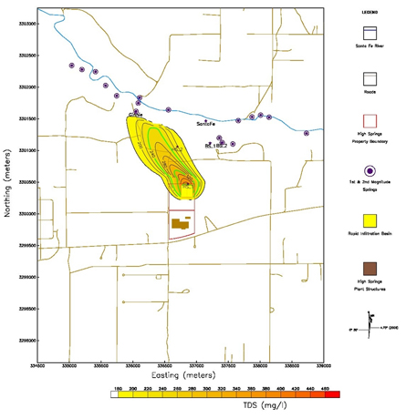
- Used MT3DMS to simulate advection, dispersion, and chemical reactions of dissolved constituents in groundwater systems.
- Projects include: simulation of TDS transport from reverse osmosis wastewater ponds (right); and benzene and MTBE transport from LUST sites.
- Routinely capitalize on GMS/MT3DMS interface to configure separate zones of dispersion and chemical reactions based on field observations or estimations.