
Rapid Site Characterization
| PROJECT NAME & LOCATION | DATE STARTED | DATE COMPLETED | |||||
| Darby Site Overland Park, Kansas |
March, 2007 | September,2009 |
| ACTIVITY TITLE | APPROXIMATE CONTRACT VALUE | |||
| Geophysical Modeling & GIS | $112,000 |
| CLIENT NAME & ADDRESS | TECHNICAL CONTACT | |||
| Delta Environmental Consultants Kansas City Office (800) 477-7411 |
Roger Lamb, R.G. (913) 422-3555 x553 rlamb@environmentalworks.com |
The Darby site is a former oil refinery in Kansas where GeoHydros has produced a GIS integrated with an in-house relational database containing lithologic, geophysical, soil analytical, and GeoProbe-MIP data, as well as EarthVision 3-D solids models of subsurface lithologic variations and contaminant distributions. The goal of the project was to produce a rapid, robust and comprehensive analysis of the site using a rapid site characterization (Triad) program and 3-D visualization of the data to guide the field work. Approximately 420,000 surface geophysics and Geoprobe-MIP measurements were modeled in 3-D. Computer scripts were written to automate model updates, output development, and project website uploads on a daily basis. The maps and visualizations provided a detailed and cost-effective 3-D understanding of the extent and magnitude of fuel impact in the subsurface that guided the field characterization program.
Many different types of spatial data were incorporated into the Site GIS such as, municipal utility lines, sewer and water mains, historical aerial images, and historical site engineering plans. Non-projected historical maps were digitized and spatially projected by identifying reference locations on roads and features common to both the historical maps and spatially projected aerial images. The GIS then provided a consistent set of diagrammatic and aerial photographic basemaps onto which all data and model output was projected for report and presentation figures.
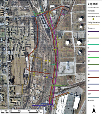
Digitized sewers and attributes from city drawings over aerial photo where line color marks sewer diameters.
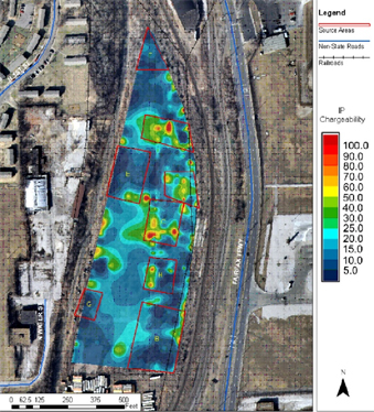
Spatial analysis of geophysical survey data related to key Site features and an aerial photograph.
We then developed a desktop, relational, geospatial database for the project that provided a single central repository for all lithologic, geophysical, MIP, groundwater level, and laboratory analytical data collected at the Site. The database was developed using Microsoft Access and Visual Basic and linked to the Site GIS thereby reducing the time required to update maps and figures with new or changed data. Additional queries were developed to produce lithologic and parametric datasets formatted for immediate upload to 3D modeling software and to develop QA/QC reports designed to confirm all data uploads and application datasets.
3D solids and parameter models were then developed to define the lithologic structure underlying the site and the distribution of soil contaminant values that were measured in the field. Correlations were developed between parametric models of the laboratory soil analytical data and the field measured parameters FID and PID. The parametric models were then used directly to define the horizontal and vertical extent of the soil contamination and estimate contaminated soil volumes above critical threshold levels specified by the Kansas Department of Health and the Environment.
We used EarthVision™ for 3D modeling and visualization to capitalize on the software's advanced visualization and most importantly its batch processing capabilities wherein computer scripts were used to automate model development, output generation, and export to a secure project website. Automation allowed the models to be updated daily, hourly in some cases, which enabled the project manager and field team to effectively use the modeling results to guide the Site characterization objectives. Model output downloaded from the project website was then used in conjunction with the GIS-generated maps and figures for project reporting and presentations wherein the automation enabled rapid edits over the ensuing year-plus reviewing period.GeoHydros successfully generated rapidly updatable, very high resolution, 3D models (0.05 foot vertical interval) of soil contamination that were considered by the project management and the regulatory agency to significantly expedite an effective rapid site characterization (Triad) approach that saved money and time and facilitated better decision making.
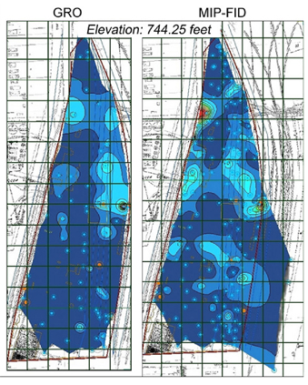 Comparison of MIP & laboratory analytical data from 3D models sliced at a specific elevation
 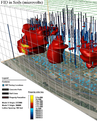 3D distribution of FID in soils where VOC contaminantion is above the State-defined threshold