|
Hazlett-Kincaid,
Inc. |
 |
|
|
NAPL Pie Shark Attack! Send Your Letters An internet-based
electronic publication of Hazlett-Kincaid. Copyright © 2001.
Hazlett-Kincaid, Inc. All rights reserved. Contact Us: ph: 717.859.1413 Hazlett-Kincaid, Inc. Comments or Questions? |
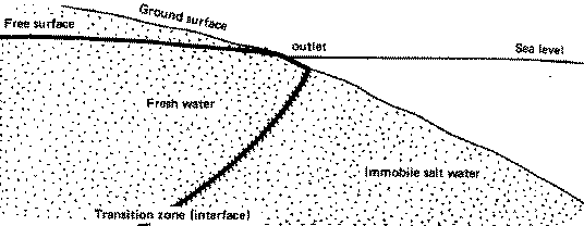
NAPL PieModeling the fate and transport of Non-Aqueous Phase Liquids (NAPLs) is no simple matter. In fact, I have encountered a lot of confusion as to what problems can be solved and what problems actually do get solved. I'll attempt to clear up some of this confusion. First off, a NAPL is any liquid that is immiscible in water. This means that it does not mix with water. Salad oil and water are an immiscible pair, which is why you have to shake the Italian dressing before putting it on your salad. If, with respect to water, the NAPL floats, it is called a LNAPL (where L is for Light). If it sinks, it is called a DNAPL (where D is for Dense). In terms of modeling, the impression I often encounter is that the fate and transport of a NAPL is directly calculated. In my experience, what the client is usually looking for, but may not have internalized, is a model for dissolved-phase components that have bled from the NAPL plume into the groundwater. Examples of this are BTEX compounds or TCE and DCE dissolving out of fuel oil or dry cleaning solvent plumes, respectively. In any event, if one can get a handle on how much NAPL is in the subsurface and the rate at which it is dissolving into the groundwater, the fate and transport problem becomes fairly straight forward and can be solved with any number of freely available codes, including MT3D and RT3D. In the event that one needs to actually calculate the movement of a NAPL plume, a different approach is required. For LNAPLs, let us consider the movement of petroleum, a problem worked out by M.K. Hubbert in his seminal 1940 paper. Hubbert demonstrated, through experiment, at least three items that are of interest here. First, LNAPLs seek the highest point, due to buoyancy forces. Second, as LNAPLs pile up, they depress the water table, which means to us that water levels taken in a monitoring well sited in an LNAPL plume need to be adjusted for density effects. Third, if the LNAPLs pile up enough, they can flow laterally under internal forces. In the early 20th century, conventional wisdom held that oil flowed underground in the direction of groundwater flow (actually, many people still weren't sure fluids flowed underground at all!). Hubbert actually used his experiments to show, for the first time, that oil moves to the high points in a system. This fact revolutionized petroleum exploration as firms began looking for oil in structural traps at high points in basins. In the environmental business, to model this problem, what is typically done is to model the location of the interface between the LNAPL and groundwater. This is done because even for a simple two-fluid system explicitly modeling the flow leads to many equations and many unknowns. For the DNAPL problem, things can get even trickier, as the DNAPL seeks the lowest point in the system. Sinking through the groundwater column, DNAPL may tend to collect in small pools (ganglia) atop the relatively impermeable surfaces of geologic heterogeneities, such as clay lenses. What commonly happens is that the DNAPL ends up in a local bedrock topographic low, where it bleeds off into solution over time. Because DNAPLs sink in water, characterizing a site contaminated with DNAPLs is difficult. Wells and borings often become inadvertent pathways for vertical flow of dense contaminants. Also, the location of dissolved or gaseous phases bleeding off of a free-product plume may not be good indicators of the plume location; a gaseous phase may seek high points and a dissolved-phase may flow with the groundwater, while the DNAPL plume seeks the lowest point. In terms of modeling, many clients I have met think that they need to model the flow of their NAPL explicitly, but this is rarely true. Most times, modeling the NAPL-groundwater interface or the dissolved-phase transport meets their needs. For those that actually need to model the movement of free product, codes such as UTCHEM will generally suffice. Typically, the user of a code such as UTCHEM will be modeling the infiltration and flow of NAPL from the time of a spill or will be testing pumping scenarios for a proposed remediation effort. Hopefully this will clear up some of the questions you may have had about NAPLs and modeling and will allow you to make more informed decisions regarding what you want from a model and what you can expect to get.§ Reference:M.King Hubbert, 1940. The Theory of Ground-Water Motion. The Journal of Geology, Vol. 48, #8, Part I, Nov.-Dec. 1940., p. 785-944. Shark Attack!Recent news reports indicated that Florida led the nation in shark attacks on humans with 10 reported attacks and 1 death in 2000. Believe it or not, shark attacks in Florida are a great indicator of freshwater discharge in coastal areas. As discharges decrease, the near shore environment becomes saltier, encouraging the sharks to venture nearer to shore.
Of these two and aside from human factors,
diminished groundwater discharge at coastal springs seems to be the
culprit for increasing shark attacks. As seen in the figure, fresh
groundwater in coastal aquifers tends to "float" on top of
the saltwater. The juxtaposition of the saltwater relative to the
freshwater in the aquifer is often referred to as the
freshwater-saltwater interface. This interface, though often
depicted as a sharp line or curve, is really a zone of mixing. Under current conditions in most of coastal Florida, the interface is likely shifted inland (to the left in the figure). This means that the toe of the interface (marked as "outlet" in the figure), may not reach the beach at all, leading to a nearly completely saltwater environment proximal to the shore. In addition to the increased near shore salinity, the shark attacks are also a harbinger of water supply problems for shore communities. As the interface moves inland, cities that are tapping groundwater supplies in coastal aquifers may experience increasing salinity and decreasing water quality. Predicting the location and movement of the freshwater-saltwater interface is a challenging problem facing many communities today. Who would have thought that shark attacks could mean so much to the groundwater community!§ Send Your LettersI am opening our newsletter to contributors. If you have written interesting articles somehow related to groundwater and would like to have the article reach our numerous subscribers, email it to me, making sure it is in HTML format if any images are included. If I like what I read, I'll put it in one of our newsletters with links back to your company web site and an email link to you. I reserve editorial over site of all submitted materials. Please limit the submissions to no more than 2 images and 200 words or less. Based on the our growing number of subscribers and feedback I have received, I think that this will provide a great opportunity for people to connect and network through our newsletter.§ Summer InternWe are currently advertising for a summer
intern. |
|

 There are two main
reasons that I can think of as to why this occurs. First, much, if
not all of Florida, has been experiencing drought conditions for
some time. This leads to a decrease in freshwater discharges to the
coast via a decline in surface water runoff and diminished flow to
coastal springs due to a decrease in hydraulic gradient between the
coast and inland points. Second, acting in concert with the drought
conditions, is the continued high groundwater use rates in much of
Florida: fountains, pools, and spring water companies are becoming
ubiquitous in Florida.
There are two main
reasons that I can think of as to why this occurs. First, much, if
not all of Florida, has been experiencing drought conditions for
some time. This leads to a decrease in freshwater discharges to the
coast via a decline in surface water runoff and diminished flow to
coastal springs due to a decrease in hydraulic gradient between the
coast and inland points. Second, acting in concert with the drought
conditions, is the continued high groundwater use rates in much of
Florida: fountains, pools, and spring water companies are becoming
ubiquitous in Florida.